Precision To Decision
We offer software services that turn your raw data in decision quality data for rapid analysis and accurate decision-making.
Analyze
Visualize
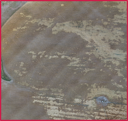
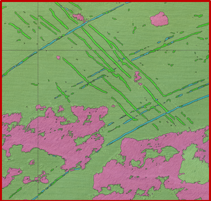
Pattern of Maneuver Analysis Tool
Smart Image Analytics
Smart GeoSpatial Analysis
Pattern of Maneuver Analysis Tool (PoMAT)

Maneuvers are Easy to Detect. Intentions are Not
Space is Highly Pattern-Friendly!
Maintain a robust understanding of satellite associations and behaviors
See More Than Just Patterns and Maneuvers
Determine satellite onboard-technologies and build alerts for activities of interest
Simple, Fast Deep Learning Analytics
Assemble Your Data
We remove the hassle and expense of building orthomosaics from all of your raw data. Our tools are built to preserve your data for future analysis.
Train Your AI Models
Take charge of your analysis by performing your own data-model development using our simple tools and instructions for pixel selection and labeling.
Classify Your Data
Find the materials, features, and conditions of interest using our advanced Machine Learning routines that with precision and speed.
GIS and Sensor Data Fusion
We solve the problem of how to display your data so you can make fast, informed decisions. Our analytics engine ensures you see either all of the data, or just the data that’s important. Spectralink is flexible, adaptive, and has a full suite of customization tools to get the most out of your data. More importantly, anyone can quickly learn the tools and techniques to turn raw data in Dashboard Decision Tools.

Connect to Data Sources
right from the Spectralink interface
Our GIS platform allows you to upload and connect almost any GIS source (raster, vector, database or map server) as well as sensor sources recording data.
Integrate All of Your Data
to ensure you have the complete picture
Download, share, or embed your GIS products via the web to almost any location. Build seamless integration between business intelligence data with location information for a more complete picture.
Create Customized Analytics
that solve the problem
Now that your data is flowing, easily build an analytics workflow using the full spectrum of datastores. Results can be displayed using a host of graphs, charts, plots and GIS overlays.
Create Customized Dashboards
that focus on the problem you are solving
Create customized, drag and drop dashboards that present both raw and analyzed data in ways that inform you and your customers without getting lost in the noise.
Make Informed Decisions
using intuitive, informative visualizations
Our dashboard tools help you create fast, informed decisions about the data that matters the most to your business.
Approach
We Create the Big Picture.

1753 South 8th Street Suite C
Colorado Springs, CO 80905
Have a Question?